The record-breaking wildfire seasons in recent years have been ravaging local ecosystems and communities around the world. From Australia to the Arctic, wildfires are becoming more intense and more frequent. With global temperatures on the rise, the need to reduce wildfire risk is more critical than ever. FireDynamo intends to do something about it and has come up with a tool to predict wildfire propagation. The bright idea caught the attention of the judges of the European space business competition Copernicus Masters.
By combining satellite data and agent-based modelling, FireDynamo was awarded the Dutch regional prize at Copernicus Masters 2022. The concept has been created by a team of PhD candidates at the VU Amsterdam. Agata Malinowska specialises in physics of living systems, Thomas Eames focuses on wildfire emissions and management, and Charlaine Roth is working on ultrafast laser physics and precision metrology. In this interview, team members Agata and Thomas reflect on their progress and explain how they use satellite data for sustainable wildfire management.
Could you take us back to the roots of FireDynamo?
Agata: It all started through exploring an entrepreneurship programme. Me and Charlaine knew each other from the corridors of the VU Amsterdam. With FireDynamo we had an idea that got us into the CERN screening week, an annual initiative to identify the potential of CERN technologies that connects entrepreneurs with technical experts. During that week, we were supported by the Amsterdam Centre for Entrepreneurship to work on a business plan and to present our idea to the CERN knowledge transfer team and other participating startups. After the CERN screening week, I convinced Thomas to join us. I knew him and his research from the PhD council. During the SBIC Ignition Programme in summer 2022, we went on to develop the tool further and then applied to the Copernicus Masters.
What does the team look like now?
Agata: In total, there are three members of the team. Thomas is the fire expert and knows how to make full use of satellite data. Charlaine is taking care of technology science from the simulation perspective. Finally, my role is to manage the overall project and drive the business plan behind it. Two members of the team are currently writing their PhD theses in different countries, but we never needed to be in the same physical place to work successfully together. Applications for other programmes and competitions such as the Copernicus Masters happened mostly online and we are pretty comfortable working in this way.
How exactly does your solution work?
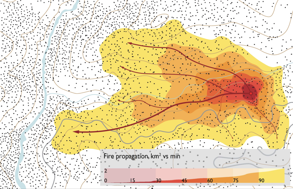
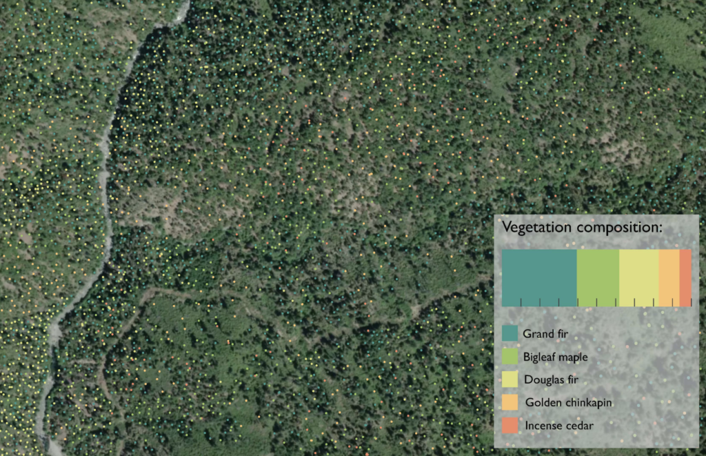
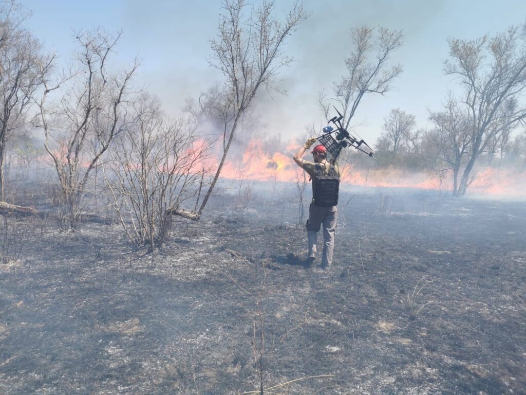
Thomas: Our software uses agent-based modelling, a computing method which makes calculations based on individual agents, such as a tree or a shrub. With this type of computer modelling, you can do near real-time fire path projections in a very accurate way and fast enough to be useful for someone to respond. You can run several simulations for different scenarios to optimise seasonal planning, to know which areas need more protection or where prescribed burning is needed. This is combined with research that uses satellite remote sensing data to map out vegetation and to ascribe properties to metre scale objects. The result is a picture of flammability, how quickly an object will burst into flames and how easily it will pass through fire to another object. This also takes into account typography, for example how the fire progresses up the side of a hill or when it hits a river. A fire will also get larger and more dangerous if it has access to more fuel (dry grass, fallen limbs and bark), and it will spread faster if the weather is hot, dry and windy. Because fire creates its own environment, it is important to have proper detection of the actual conditions. Feeding all this information into the model allows for optimised emergency systems and improved hot spot detection. We can also perform seasonal evaluation and identify high-risk areas and get better insights into preventive measures, such as where to cut vegetation in order to create a firebreak. Finally, it also provides real-time projections on how to effectively respond, where to allocate resources, and how to spread them most efficiently to maximise damage prevention.
Which satellite data sources do you use?
Thomas: Copernicus is the work horse. Apart from Sentinel data, Landsat data are also freely available and provide a solid basis. Other options, such as Skysat, provide higher resolution but with commercial data we have to be a bit more selective.
Agata: The Copernicus Emergency Management Service is also important to validate our methods. Using historical data sets, we can check if what we have predicted is actually aligning with what happened. Who knows, in the future FireDynamo might be added as a feature on the CEMS platform.
Who will be using the solution?
Agata: In the first place, we aim to lower the risk of fire and increase awareness among land managers, private landowners and national parks. Insurance companies are a big part of the market too. For us it is crucial to understand customers and their day-to-day struggles. We plan to work together with the users. We already collaborate with a few research groups specialised in fire management. Researchers are well informed about the struggles of the daily operations and also give us a lot of valuable insights.
What is the biggest challenge that you face in fire risk assessment?
Thomas: A lot of places are suffering from fire. Infrastructure and wildlife are under threat. One problem is the lack of the right kind of fire as a rejuvenating process. It is hard to get the balance right. We want to assist fire departments and protect valuable infrastructure and people’s lives. On the other hand, we also want to help land managers to confidently use fire in a way that they won’t threaten valuable assets. In Europe, we have been trying to avoid fires at all cost but eventually suppression of fire will not be enough. We will also have to learn how to manage it. I think it is important to communicate about that. Fire is an emotionally charged subject for many people, and sometimes emotions can lead to mistakes in decision-making. I am working on a podcast where we look at local context of fire and which options might be more or less effective for the local landscape to spread understanding amongst communities. This should also help grease the wheels of political decision making if we can drum up support for scientifically-sound choices.
Where are you planning to bring your service to market?
Thomas: We are focusing on Europe. Initially, we were thinking Australia would be a good place to start because there is a lot of funding available. Big discussions are ongoing there about fire management. However, the whole country operates differently. Every individual state has different protocols and attitudes towards fire management. What works in one state is not directly transferable to another. We would need to be very adaptable and flexible to make it work for every state in Australia. Having done that research, the focus now is much more on the European market, which is simpler and more familiar with room for growth compared to a somewhat saturated market in Australia. Europe is also providing a lot of support for climate mitigation and climate change adaption.
What was your overall experience of the Copernicus Masters?
Agata: We really enjoyed the process. It wasn’t easy, but it allowed us to shape our idea nicely. Last year, we first went through the SBIC Ignition Programme. There, we learned how a startup works from a practical side, how to set it up legally, and how to involve different partners. It showed us the do’s and don’ts on how to run a company. Having office space in Noordwijk and access to hands on training sessions, the programme also helped us to formulate our concept and value proposition. In the end, we were well prepared for the interview questions of the Copernicus Masters. Apart from the Dutch regional prize, we also got to the final round of the DLR Environment, Energy & Health Challenge. It was interesting to see that the questions for the Dutch prize were more business oriented, while for the DLR Challenge they were more technical. To be an overall winner, I think you really need to nail both types of interviews. Finally, we also enjoyed the award ceremony at the New Space Economy ExpoForum in Rome. It was a very fun crowd to meet.
Thomas: As a startup, you have this long-term plan and it becomes very hard to celebrate all the little things along the way. With successful applications and awards such as these, it is good to have a pat on the back every once in a while to keep you motivated.
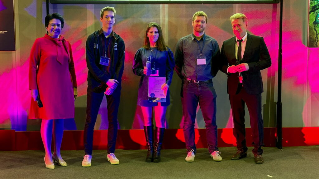
The competition helped us to define our idea and unify as a team to eventually get to a shared ethos.
Thomas Eames
What advice would you give to potential participants of the Copernicus Masters?
Thomas: Just apply. The process allows you to get things straight. Getting the house in order was the main benefit for us. We aligned as a team. The competition helped us to define our idea and unify as a team to eventually get to a shared ethos.
Agata: And it forces you to consider how you are going to make an impact. In my experience, the competition attracts entrepreneurs in different stages. Some have an idea in a very early phase, others are already running and growing a business. It is difficult to compare those levels, so when you apply, just focus on how you are going to bring change.
What are some entrepreneurial lessons you have learned?
Thomas: We are all coming from an academic background and moving into business. As scientists, we were used to find nuance in everything, nothing is a strong conclusion but that is not how you sell an idea. Sometimes you need to blow your own trumpet. In the world of business things are less critical, a “can do it” approach is more important.
Agata: Push yourself out there, apply for different programmes and expose yourself.
What will be the next step?
Thomas: We are now still working on a proof of concept. It is important to have a working algorithm and simulation, and to be able to validate real-life data from past fires. From a market perspective, we are still doing research on the customers segment, originally targeting private land owners but maybe also insurance companies.
Agata: One of the next steps on our radar is the incubation programme of ESA and maybe apply to ESA BIC Noordwijk or one of the ESA BICs in Germany in the proximity of potential customers (i.e. National Reserves). In any case, we look forward to continuing our growth path.
Links:
Website: firedynamo.com
Socials: linkedin.com/company/firedynamo
ABOUT THE COMPETITION
The Copernicus Masters organised by ESA and AZO is the leading international innovation competition at the forefront of Earth observation data utilisation. Over 620 participants from 47 countries participated in the latest edition of the Copernicus Masters. A total of 143 new Earth observation business cases and application ideas were submitted in 2022. Green City Makers was selected as the overall winner of the competition. Next to the overall prize and specific partner challenges, the competition also included 14 regional prizes. The organisers of the Dutch prize – Netherlands Space Office (NSO) and SBIC Noordwijk – selected FireDynamo as the regional winner offering them a cash prize, office space and more. First runner-up greenify.ai was also rewarded with a ticket to the SBIC Ignition Programme and free community membership.
The Copernicus Prize the Netherlands was organised by the Netherlands Space Office (NSO) and SBIC Noordwijk.
The Copernicus Prize the Netherlands was also made possible thanks to our competition partners: ANWB, ESA BIC Noordwijk, HE Space, Netherlands Space Society, NL Space Campus, Rabobank and Zuits.
