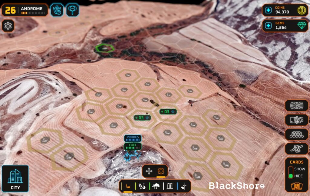
The European Space Agency’s Business Incubation Centres (ESA BICs) are catalysts for innovation and fostering space related entrepreneurship. These centres provide essential support, resources and guidance to startups with groundbreaking ideas. Here, we highlight the inspiring journey of Hans van ‘t Woud. With the help of ESA BIC Noordwijk, Hans transformed his academic project into a thriving business. The incubation programme enabled Hans to develop his company BlackShore and launch an innovative Earth mapping game that leverages satellite imagery for various applications.
Originally published on the ESA Commercialisation Gateway website.

The beginning of BlackShore
This story exemplifies how ESA BICs are instrumental in turning visionary concepts into impactful solutions, driving progress in the space industry and beyond. When Hans van ‘t Woud was creating a computer game with satellite images of Mars for his master’s thesis, he knew he had found his passion. Freshly graduated, armed with his thesis paper and a first version of his game, Hans showed up at ESA BIC Noordwijk. “I knew nothing about companies, I knew nothing about entrepreneurship, and I knew nothing about ESA. All I wanted to do was to continue with Mars,” Hans recalls.
Levelling up in satellite imagery
Hans quickly learned that the real need for satellite imagery was much closer by, right here on Earth. After getting selected for ESA BIC in 2011, the incubator supported Hans as he developed his company BlackShore. Throughout the programme, his initial approach transformed into an Earth mapping game – Cerberus –that was also supplemented with e-learning and players receiving points for correct identifications. With the vast amounts of satellite imagery available, applications here include food security, to understand climate change or efficient farming.
The game acts as a crowdsourcing platform for “citizen science” – where players explore satellite images and need to identify certain characteristics, such as terrain features, crops or anomalies. Each new satellite image offers a completely different environment for the players to explore. Using the power of the crowd, this allows for large amounts of data to be added that can enhance satellite images.
“The e-learning part is really important – teaching people quite difficult things about the planet”
Hans van ‘t Woud
One of Hans’ personal highlights was getting to experience the capabilities of his game first-hand. At Mars Desert Research Station in Utah, USA, Hans joined five other analogue astronauts to simulate a Mars mission in the rugged desert landscape. Using his crowdsourcing platform, Hans asked the players of his game to map the area around their analogue “space” station, which included similar terrain features to a Martian environment. He is proud of how this proved his technology: “The people were mapping with the game at home, finding anomalies and then, in the station, we could visit those locations in the Utah Desert. This was really cool because they were actively steering us as astronauts, and then we could send images back home to the crowd from these coordinates. It really worked!”
Mapping a changing world
With his technology proven to successfully identify points of interest, the game has also benefitted from the improvements in satellite image quality over the past decade. While in the game’s early days, players were working with 50-centimetre resolution, this has since improved to 30-centimetre resolution. The first time using these higher-resolution images was particularly exciting for Hans. In a project by the African Development Bank, new pumps, roads and dams were built in Niger. When they asked the crowd to map the changes between 2016 and 2021, these were clearly visible. “You could actually see people going to the markets, you could see some prosperity and that is really nice. The crowd loved to map that,” he adds.
Alongside the changes in image quality, advances in artificial intelligence (AI) also have implications for the game. In a project with ESA, Hans’ crowdsourcing platform helped train an AI to measure the impacts of climate change on durum wheat production in the Mediterranean. He is proud of the project: “The outcome was a total of 250,000 new data labels released as open data. This is free data for researchers to play with, or you can also now, in theory, use those labels to create your own fake worlds or simulations of climate change.”

Successful application: In 2021, ESA BIC aumnus BlackShore created a new map in the Earth observation computer game Cerberus. This map covering the Italian region of Puglia was made available to the the player base of more than 70,000 people. The goal was to map the types of crops and measure the impact of COVID on the ability to grow said crops. The project was supported by ESA ESRIN and a similar project of BlackShore was concluded at that time in Ethiopia. blackshore.eu/projects
Learning along the way
Being able to learn new things and develop skills further is something Hans highly values about his entrepreneurial journey through ESA BIC. From his time during – and after – his incubation period, having an office on location helped expand his view of the space industry. While it has not always been easy, challenges along the way and leaving his comfort zone are what helped him grow: “I don’t think I would have done anything differently. Things were unplannable and that’s actually what I like, I just like this adventure.”
However, he warns about not internalising the difficulties that come with being an entrepreneur: “Maybe you do not want to show to the potential investors you are vulnerable, you are struggling with things, and maybe you don’t want to share it with your friends or your family. I think it is still very important to pay attention to your mental health and get support if you need it.”
Looking into the future, Hans knows what his dream is – to go back to the game’s roots and develop applications for the game on Mars. “There are also interesting things on Earth, but my real heart is over there,” says Hans. For now, he is happy that he can further spread knowledge about our planet: “I get to educate people about Earth and that is what I like. The e-learning part is really important. We are actually teaching people quite difficult things about the planet.”
About BlackShore’s product: Cerberus is a geospatial-based crowdsourcing platform in which the “brain power” abundantly present in the gaming industry is put towards good causes. BlackShore delivers accurate, up-to-date and low-cost map products based on the crowd-sourced interpretation of satellite, aerial or drone imagery. The application maps what matters most in the world. Topics range from climate impact monitoring, disaster relief and (food) security. blackshore.eu/projects
This article was written for the occasion of the 20 years anniversary of ESA BIC and published on the ESA Commercialisation Gateway website. For more ESA BIC success stories, go to the LinkedIn group by clicking on the banner:

Recent news:
20 years of ESA BIC: “Startups foresee the big trends in space”
Prepare your space business idea for lift off!
Discover everything you need to know about the ESA BIC Noordwijk programme.


